


Geotagging+
Description de Geotagging+
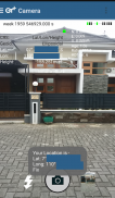
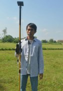
This app allows you to take image and measure with low-cost GNSS module (like U-blox GNSS module or E-GNSS from potretudara : http://www.potretudara.com/low-cost-gps-gis/ ). Measured coordinates from low-cost GNSS module are stored to EXIF image metadata in time when you tap the "capture" button. Use this to create your geotagging more precise to sub-meter level. Very useful for census, GIS support, reporting issue, and others.
You can still use internal GNSS for geotagging by deactivate BASE and ROVER in the Input Stream menu. Obviously none of the precision algorithm found in RTKLIB can be use.
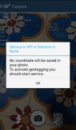
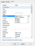
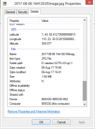
Image taken by this app will have coordinate metadata, accuracy, and solution type (internal, single, float, or fix).
Heavily based on RtkGps+ from Ronan LE MEILLAT, this is a fork of his work. Original licenses are in the "About/Legacy Info" screen. Thanks to all contributors to respect this clause.
This app is RTKGPS+-like with additional Camera menu. You still can use this app for surveying, tracking, etc. like RTKGPS+ do.
This app is a port of RTKLIB 2.4.3b 28 developed by Tomoji Takasu (http://http://www.rtklib.com/). This RTKLIB 2.4.3 is modified by rtklibexplorer and named RTKLIB 2.4.3 demo 5 b 28 (https://github.com/rtklibexplorer/RTKLIB). If you do not know what this application is, this application is probably not what you are looking for!
App manual : http://bit.ly/shortmanual
Cette application vous permet de prendre des images et de mesurer avec module GNSS à faible coût (comme module GNSS U-blox ou E-GNSS de potretudara: http://www.potretudara.com/low-cost-gps-gis/). coordonnées mesurées de module GNSS à faible coût sont stockées des métadonnées d'image EXIF dans le temps lorsque vous appuyez sur le bouton « capture ». Utilisez cette option pour créer votre geotagging plus précis au niveau du sous-mètre. Très utile pour le recensement, le soutien SIG, question des rapports, et d'autres.
Vous pouvez toujours utiliser GNSS interne pour geotagging par Deactivate BASE et ROVER dans le menu flux d'entrée. De toute évidence, aucun de l'algorithme de précision trouvé dans RTKLIB peut être utilisé.
Image prise par cette application sera coordonnée des métadonnées, la précision et le type de solution (interne, unique, flottant ou fixe).
Fortement basé sur RtkGps + de Ronan LE MEILLAT, c'est une fourchette de son travail. licences originales sont dans l'écran « A propos / Héritage Info ». Merci à tous les contributeurs à respecter cette clause.
Cette application est RTKGPS + -comme avec un menu de caméra supplémentaire. Vous pouvez toujours utiliser cette application pour l'arpentage, le suivi, etc. comme RTKGPS + font.
Cette application est un port de RTKLIB 2.4.3b 28 développé par Tomoji Takasu (http: // http: //www.rtklib.com/). Ce RTKLIB est modifié par 2.4.3 rtklibexplorer et nommé RTKLIB démo 5 b 2.4.3 28 (https://github.com/rtklibexplorer/RTKLIB). Si vous ne savez pas ce que cette application est, cette application est probablement pas ce que vous cherchez!
Manuel de l'application: http://bit.ly/shortmanual
Geotagging+ - Version 1.1
(29-06-2018)Geotagging+ - Information APK
Version APK: 1.1Package: com.geotaggingplusfreeAncienne Version de Geotagging+


 4.34
4.34


 4.63
4.63
Applications de même catégorie

Vous pourriez également aimer...


